- In the 12 miles we’d only seen four other walkers.
- Planning ahead of trips allows you to get the most out of your time away and can be part of the enjoyment.
- Quite simply, nothing beats good planning.
- I’ve found the boat and engine combination an excellent compromise of cost, size, portability and capability when used within its operating limits.
West Coast Adventure
Peter Talbot recounts the tale of his 65-mile, five-day journey from Arisaig to Sligachan in a 3m Zodiac SIB through some of Scotland’s remotest and most spectacular scenery.
Since discovering that mainland Britain’s remotest pub, The Old Forge at Inverie (on the Knoydart peninsula), is an 18-mile walk from the nearest road, and yet only 5 miles by sea from Mallaig, I’d planned to investigate this remote region of Scotland further. Research showed that the area north of Mallaig promised impressive mountain scenery with an interesting coastline that would make a great follow-up journey to my Norwegian fjord adventure (see PBR issue 124) in my 3.1m Zodiac inflatable. So when Graeme (my most frequent crewmate in the 10 years I’ve had Zodiacs) agreed to the plan, we fixed a week in July and the trip was on.
Ready to start packing the car the day before departure, I turned the key in the ignition and found the battery had chosen that day to give up – a little inconvenient, but at least it wasn’t the morning of the day after. A quick jump start and return trip for a new battery had me packing the car only 30 minutes later. Having already undertaken five multi-day Zodiac/camping journeys along similar lines (i.e. the Caledonian Canal twice, the River Thames, the Göta Canal/lakes in Sweden and Norwegian fjords), loading the car has become a fairly well-practised routine.
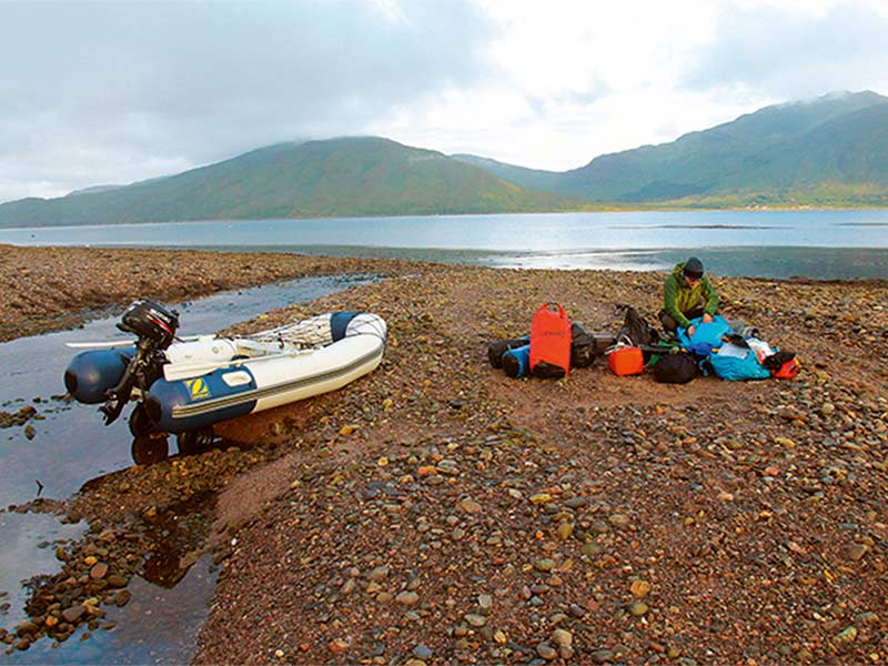
I’d pre-booked our first night at Camusdarach campsite, Arisaig, as while there are several sites in the area, it was peak season and I wanted to guarantee a pitch on a site with both beach access and somewhere to leave the car for a week in our absence. After arrival, a busy couple of hours saw the tent up, bags packed and the boat made ready for the next day. The friendly campsite has its own quiet beach three minutes’ walk from the tent pitches. We moved the boat by hand along an undulating grass track, to near the start of the beach.
The forecast for the next morning was good, so with a calm sea and light winds we launched early and departed at 08.00 bound for our next campsite at Inverie (close to The Old Forge). We passed Mallaig, after slowing to let a ferry bound for the harbour pass well ahead. Turning east into Loch Nevis (Nevis meaning ‘Heaven’), we experienced a little chop caused by a slight wind coming from the east. Crossing safely, we entered the large bay and approached Inverie, before heading past the village to Long Beach campsite. The clear water meant we could see the seabed while still around 200 metres off the shore, so we proceeded cautiously in case it got shallower, but with the tide high, and the bottom of the bay being very flat, there was sufficient depth for the engine right up to where the beach rose slightly and the campsite began. A few yards back from the beach (with excellent views of the surrounding bay and mountains), the idyllic campsite consisted of several pitches (only three were occupied), where longer grass had been kept short, and two cabins (both with turf roofs), one holding a modern high-tech composting toilet and another for eating in, with a washing-up bench and tap round the back. The sign on the tap said that while the water was the same as that supplied to everyone on the Knoydart peninsula, as it came from an untreated natural source, users were advised to boil it before drinking. Working out at only £3.50 per person per night, this campsite had everything we needed, and was ideal for us.
Checking the weather that night in the The Old Forge on their free Wi-Fi, we decided on a walk around the peninsula the next day, as winds were going to be too strong for us on our journey north. Our 12-mile circular route followed a single-track road from Inverie to the sheltered bay at Airor, then became more ‘off road’ along the shoreline, and required a river crossing just before Inverguseran. Opting to cross at a shallower, slower-moving but wider point, our progress without shoes (we wanted to keep them dry for the remaining 6 miles) wasn’t fast over the greasy rocks, but we made it without any slip-ups. In the 12 miles we’d only seen four other walkers.
With the winds dropping that evening, we spotted a weather window for the following day, which would give us plenty of time to reach Glenelg (20 miles away). As usual, we took the precaution of identifying several other places to stop and camp en route, in case changing weather also required a change of plans. To take advantage of the start of the best of the weather (forecast to start around 6.00), we’d be departing at low water, meaning that although we’d have some distance to get everything to the water’s edge (the flat bottom of the bay meant the tide went out a long way), we’d have the benefit of a flooding tide once afloat, helping push us north-east up the Sound of Sleat. Waking just before 04.00, we had everything by the water’s edge (after a portage of around 150 metres) by just after 05.15. With no mobile signal, I logged a passage plan with Stornoway Coastguard from the payphone at the nearby youth hostel, and when they said VHF cover was poor in places on our intended route, I said I’d keep them informed of our plans by telephone. We launched and loaded the boat, and as it approached 06.00 we paddled beyond the shallows before starting the engine.
Making good progress, we rounded the dramatic end of the Knoydart peninsula (with its rocky islands) without a problem, and were soon in the Sound of Sleat. With the tide filling and slight wind and swell from the south-west, we were helped on our way, soon passing our lunch spot from the previous day at Airor. The scenery around Loch Hourn (Hourn meaning ‘Hell’) was very reminiscent of the fjords last year, but, keen to make progress in the favourable conditions, we crossed its mouth and continued on our way. Passing between the Sandaig Islands (near where Gavin Maxwell lived while writing Ring of Bright Water), we did the remaining 5 miles to Glenelg, noticing an impressive waterfall on the east shore just before our arrival. With the tide now nearing high water, we were able to easily enter the natural lagoon created by beach shingle in front of the Glenelg Inn, where the owners had previously kindly agreed we could camp in the inn’s garden. Having completed our planned distance for the day, and with the wind beginning to build again, we were happy to set up camp, as although it was still before 10.00, we’d already done a near six-hour shift.
As in Inverie, stronger winds forecast for the day after arrival meant we decided to stay a couple of nights. This gave us time to see some of the local area and enjoy a couple of evenings in the Glenelg Inn – a very traditional, popular and friendly Highland inn, complete with roaring fire. The village of Glenelg is known for the small locally owned and operated car ferry to Skye, which is run across Kylerhea. Glenelg has two brochs (fortified stone round houses built approximately 2,000 years ago), Dun Telve and Dun Troddan. Among the best remaining on the Scottish mainland, these are well worth the hour walk from the village. In 2012, Glenelg, in association with the missions of the Mars rover Curiosity, was twinned with Glenelg on Mars, and a ceremony was held in the village to mark the event.
With the forecast for the following day set to improve dramatically, we rechecked the tide times for getting through the narrows of Kylerhea. With tidal currents reaching 8 knots in peak flow, we wanted to transit near slack water. So, with an excellent forecast, we chose another early start to meet the 07.00 tide window, to make the most of our last day on the water for this trip. The low tide meant the lagoon’s water level was nearing empty, so the boat had to be partly wheeled/floated across to the gravel banks before it could be fully launched, with us carrying the gear round separately.
Getting away after logging a broad passage plan with Stornoway Coastguard (covering the various options we’d been considering), we passed easily through Kylerhea with no discernible tidal flow, noticing a large number of jellyfish just before we exited into Loch Alsh. With the great weather set for the rest of the day, we chose to make the most of it and press on west to Kyle of Lochalsh (where we topped up with fuel). Passing under the Skye Bridge we continued to head west, watching the Isle of Pabay go by and enjoying the magnificent scenery all around us – including the high peaks of the Red Cuillins on the Isle of Skye in front of us, and views north-west to the Isle of Raasay and north-east to Plockton and beyond. We headed between the Isles of Scalpay and Skye and, having easily passed some of the camping options we’d identified earlier, decided to make for the campsite at Sligachan. While we knew access from the water wouldn’t be as straightforward as it had been with our previous campsites, we also knew we’d have great views of the Black Cuillins. Once at the end of Loch Sligachan, our shallow draught allowed us to get a little way up the Sligachan river, and from there we relayed most of the gear on foot to the campsite. At around half a mile, this overland section was a little further than we’d hoped for, but it was soon done. We took the boat off the water later that evening at Sconser and got a lift from the kind owner of the campsite back to the site. Encountering midges in sufficient number to warrant donning head nets for the first time, we cooked our evening meal.
As on my previous A to B boat journeys, the penultimate day was spent recovering the car. Getting an early bus to Armadale, I then caught the ferry to Mallaig (where I can recommend the cooked breakfast at the Fisherman’s Mission), followed by a taxi back to the car at Cambuslang campsite. As I hadn’t booked a ferry crossing with the car (not being sure where/when we’d finish our journey), I chose to drive back on the longer road route, via Fort William, and over the Skye Bridge, rather than retracing my route from that morning, which would have required waiting some time for an available space on the ferry.
With the car back at the campsite, live music in the nearby Seumas Bar adjacent to the Sligachan Hotel tempted us to treat ourselves to our first ‘meal out’, and we enjoyed an excellent dinner to mark the end of our journey.
How this trip compared with earlier trips
With similar mountain scenery to what we’d experienced on earlier trips, we knew there’d be the potential for associated ‘mountain-type’ weather. The main difference this time was the need to take stronger tides into account. I’d previously only experienced tides on coastal day trips as we’d had virtually no tidal effects in the Hardanger and Akra fjords, and none on trips on the River Thames, the Caledonian Canal or the Swedish canals/lakes. Tidal currents can be strong on the west coast, so we avoided peak flows (which meant planning ahead and some early starts). The associated tidal range meant we used our ‘detachable’ launching wheels to get the boat/engine out of the water and above the high-tide mark overnight. This allowed us to camp near the boat on sites near the water, rather than requiring us to find jetties/pontoons to tie up to (which aren’t always around in this more remote region) and then camping elsewhere. The tidal range and seabed profile meant in some places the tide went out a fair distance, so the boat and bags had to be relayed up/down the beach over several trips.
The weather intervened more than on previous journeys, with strong winds giving us a couple of days to explore local places of interest, which isn’t something we’ve always done as much of on previous trips, as we’ve tended to move on with the boat each day. The excellent weather experienced on our last day had stood out on the forecast for several days beforehand, and allowed us to enjoy the fantastic Isle of Skye scenery at its best.
Without the need for overnight car ferries and extensive road journeys (unlike the trips in Norway and Sweden), or the requirement for boat licences (like the Caledonian and Göta canals, and the River Thames), the cost of this trip was one of the lowest yet, and the journey was a truly memorable adventure through some of Scotland’s more remote areas and spectacular scenery.
The Knoydart peninsula
The rugged 85 square miles of the Knoydart peninsula includes three Munros (mountains over 3,000ft) and is a designated National Scenic Area. With the only overland route to it being an 18-mile walk from the nearest road, Inverie (with a population of approximately 50) has a strong ‘island’ feel about it. Frequent passenger/supply boats connect its pier and slipway to Mallaig, so if we’d needed we could have used this service to get back to Mallaig. Vehicle transportation is available via landing craft-type vessels, though with only a short road network on the peninsula, users will mostly be local traffic and service vehicles. In 1999, the Knoydart Foundation bought out the Knoydart Estate, which covers most of the peninsula. Among the aims of the trust is the preservation of the local landscape, wildlife and cultural heritage.
Coastal wildlife in the area
A rich variety of wildlife can be seen on Scotland’s west coast. The main animals you’re likely to spot include seals (both common and grey) and a range of seabirds. Otters can sometimes be seen, and also porpoise, dolphins and on occasion whales (the minke whale being the most common around Scotland). There’s also a chance you may spot a white-tailed (sea) eagle, which is the UK’s largest bird of prey.
The boat and engine
The Zodiac Cadet 3.1m inflatable (with wooden floor) can carry five people. It has two main inflation chambers, and an inflatable keel (giving shape beneath the floor, to improve performance). With two people on board, there’s sufficient space for a week’s camping equipment/supplies. Rolled up, the boat fits into a standard hatchback car and can be inflated and made ready in around 30 minutes. While the boat can take up to a 15hp outboard, the 6hp provides enough power on my trips, and uses around 0.3 litres per mile (in journey/camping mode). My boat was bought new from PA Lynch Ltd, who also fitted the removable transom wheels and under-seat anchor points for the fuel tank. While obviously not as seaworthy as a larger RIB, and shorter than other inflatables such as the Vanguard 435 and 4.8 Humber (see PBR issues 129 and 126), I’ve found the boat and engine combination an excellent compromise of cost, size, portability and capability when used within its operating limits.
Summary of costs for the seven-night trip
The breakdown of our total costs for the seven-night trip is outlined below (the cost for Graeme and me, each, is simply the total, split in half).
- Fuel for car = £91
- Fuel for boat = £23
- Total spent on camping = £69
- Food = £80 (not including a pub meal on the last night)
- Public transport back to car = £22
- Total cost = £285
- Cost per person (based on two people sharing costs) = £285/2 = £142.50.
Planning a trip yourself
As well as being essential for safety purposes, planning ahead of trips allows you to get the most out of your time away and can be part of the enjoyment. Quite simply, nothing beats good planning. Some of the main steps involved include:
- Finding an interesting and suitable area that’ll be within you and your crew’s experience and skills, and also within the capabilities of your boat.
- Examining charts, maps and books (and combining the different types of information they provide) to identify realistic day passages and accommodation options for yourself and your boat (but that also offer plenty of safe ‘bailout’ options if weather deteriorates). Charts provide buoyage, tidal (strength and direction) and depth information, while maps provide useful supplementary information such as the positioning of roads, paths, campsites and even public phone boxes (should a mobile signal not be available). Sea kayak guides can also provide excellent information. Simon Willis’s superb Scottish Sea Kayak Trail book does so, and explains the tide directions and strengths in the area of our trip (and beyond).
- Investigating campsites. Are they located near the water’s edge? Are there temporary moorings, a pontoon or a slipway? Do they recommend booking ahead or can you just turn up (which makes things more flexible). If you’re planning to wild-camp, consult access regulations (see link below).
- Checking where you’ll get any necessary supplies on the way (e.g. drinking water, food and fuel, and even weather forecasts).
- Establishing how your overland travel will work (where you’ll launch, leave the car, and how to get back to it at the end if it’s an A to B trip).
- Ensuring you have the necessary documentation (e.g. third-party insurance for some managed waterways in the UK).
- Producing checklists to ensure you don’t leave anything at home.
- Planning how you’ll get the latest weather forecast information (Wi-Fi, mobile phone, VHF, FM radio or payphone?), and how you’ll keep the coastguard and someone at home aware of your plans.
For a suggested kit list and further safety considerations, see ‘Norway Adventure’ (PBR issue 124).
Useful links
Mainland Britain’s remotest pub – www.theoldforge.co.uk
Knoydart Foundation – www.knoydart-foundation.com/coming-to-knoydart/other-accommodation/camping/
Related Posts