- Mousehole brims to the rafters with maritime folklore and is steeped in seafaring history.
- Kynance’s rock formations are a princely wonder to behold.
- Thatched roofs, whitewashed walls and little gardens bright with flowers contribute much to Helford village’s picture postcard beauty.
- Cornwall’s natural reserves had shaped its people and borne an influence far beyond the banks of the Tamar.
- Cadgwith may be small in form, but its beauty is great and rich in detail.
Join HMS as he takes us on a voyage of discovery in search of the ‘cream of the county’, the best-kept coastal secrets of Cornwall – a land famed for its myths and legends, but a realm too that gave birth to mighty machines and delivered resources to empower armies and empires.
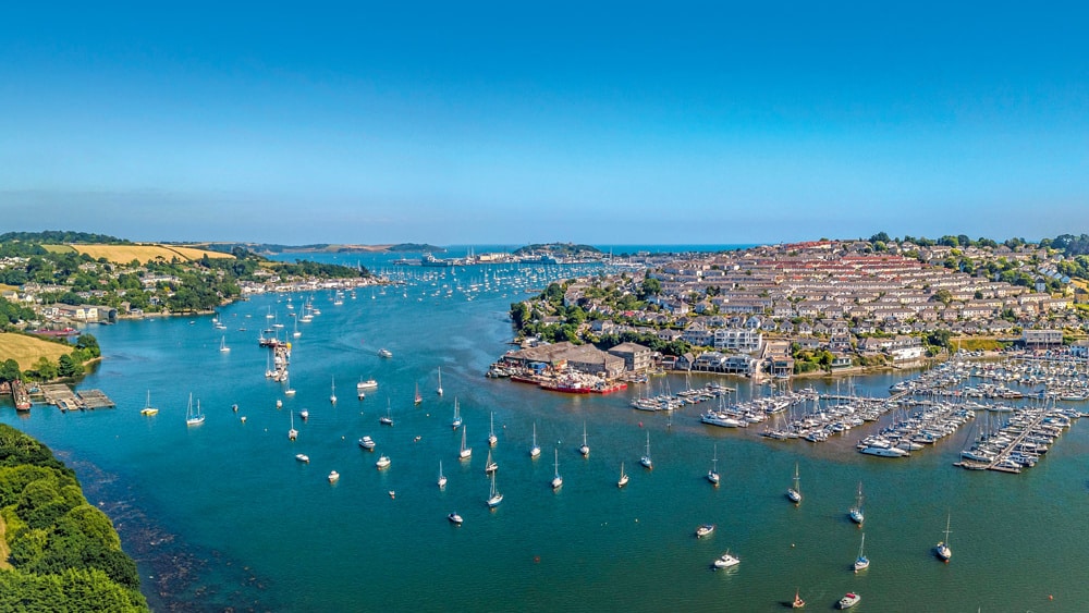
Cornwall is a county known the world over for its association with the sea. Its coastline in particular is remarkable in its beauty and comes bound ‘hand in hand’ with tales of smugglers, wreckers, fishermen and privateers. Indeed, it is this mix, this colourful and interwoven tapestry of life washed by the tide, that holds such an allure for both landsman and mariner alike. Cornwall – or Kernow, as it’s known in the Cornish tongue – is synonymous with legend, famous for its tales of heroes, giants and fairy queens, of mischievous pixies and seductive mermaids. Its natural remoteness and connections with antiquity help feed such tales and inspire in the hearts of both its native inhabitants and those outside this princely realm superstition and a fascination with fable.
For centuries, Cornwall was like an island. With its landlocked boundary to the east, drawn by the moorland waters of the River Tamar and all around its remaining borders, abutted by no county or shire, Cornwall’s extremities only knew the ocean. Before the railway and the great industrial revolution of the late 1700s, Cornwall was out on a limb, set hundreds of perilous miles and many days’ ride away from government and the nation’s capital. Like Cornwall’s closet cousins, the Welsh, the Cornish people saw themselves as a race apart, one that relied upon the seemingly unending rich natural resources of their dominion and their own profound resourcefulness to survive off such. Why, they even had their own proud language …
Tin mining in Cornwall dates back further than records of the region began. But there is evidence that the vast reserves that began to be mined here some 3,000 years ago were responsible for changing the fortunes of the ancient world. Tin was a revolutionary component, and, when forged with copper, made bronze – a new metal that was responsible for igniting a global arms race. Any nation having designs on becoming the next world power wanted this new super-material in order to equip its armies with bronze weaponry – in particular, arrowheads, swords, shields and spears. Bronze was the first metal to transform the fortunes and possibilities of advancement, not only in war but in agriculture and culture too.
How strange, then, that this ‘edgeland’ of Britain, this Cornwall, home to a race supposedly so insular that they still speak their own language, should be sat on such world-changing fortunes! Yes, it was Cornwall and the Cornish who became famous the world over for being the most bounteous supplier of high-quality tin – and, to a degree, copper too. Furthermore, in their trading with the developed world at that time, notably those countries of the Mediterranean region, including the ancient Phoenicians, the Cornish were exposed to, and had an intimate association with, an extraordinary mix of foreign peoples and cultures. Long before the bedraggled Spanish survivors of the Armada were washed up, captured and then integrated into many rural Cornish bloodlines, the ways of the Cornish were influenced both culturally and biologically by their exposure to cosmopolitan life. But as always, all such fortunes came and went by way of the sea.
In the early 1800s, as the tin mining industry in Cornwall began to dwindle in the face of cheaper foreign alternatives and the mines started to feel the first bites of a harsher marketplace, the coal mining industry of Wales began to thrive, fuelling the Industrial Revolution and a British Empire that at long last would not only see off the French but go on to dominate the globe right through the Victorian era. During this latter period, though, another Cornish industry began to flourish like never before, and as the glitter of tin waned inland, out at sea another haul was being made – one that once again flashed with brilliance resembling that of a precious alloy.
‘Silver beauties’, as the great shoals of pilchards were known, were fished by the millions, and it was believed that they and the rest of the ocean’s vast reserves were inexhaustible. Though the Cornish had been fishing commercially on a small scale since the 16th century or even before, as ways and means progressed, by the 19th century Cornwall had, like other regions around our coast, a true fishing ‘industry’ to manage, with whole villages and towns such as Mevagissey, Polperro, Mousehole, Newlyn and Port Isaac being completely dependent on the pilchard trade. These communities both prospered and starved, became enriched and impoverished, as a result of the sea’s bounty. Once again, Cornwall’s natural reserves had shaped its people and borne an influence far beyond the banks of the Tamar.
Nevertheless, by the time the First World War struck, the Cornish fishing industry had begun to fall into serious decline as the fish stocks were decimated by overfishing. No more ‘hue and cry’ from the cliff tops, no more excited shouts in the village streets at a shoal being sighted off the cove. How strange it was that literally overnight it seemed that the ‘silver beauties’, which so many communities depended upon for their very survival, were never seen again and never did they return. It was as if the pilchards knew they had to escape the clutches of man. The market collapsed, and with the passing of the great smack and lugger fleets with their rust-coloured sails plying the seas, steam power, with its funnels and smoke stack trails, began to mark the horizon instead. A new age was dawning and ‘old Cornwall’ began to slip from view, following in the wake of the ‘silver beauties’, with the onset of tourism fanned into life by rail links and the motor car.
Crystal Coves & Rock Pools
It’s true to say that the appearance of our seas and much of the coastline remains timeless. Even in my experience of growing up near Lantivet Bay just east of Fowey, I can to this day walk down the old drovers’ lane, across the fields and on down a cliff path that hasn’t changed in over 50 years. The thick clumps of yellow gorse, banks of foxgloves, campion and bluebells, even the contorted forms of wind-blown thorn bushes and stunted oaks, are exactly as I remember them as a boy back in the 1960s. To walk this coast and search out its ‘nooks and crannies’ by foot is a joy indeed, but to see the coast from the deck of a boat, now that is a privilege.
A little-known gem I want to share with you is Palace Cove. This tiny cove is located about a mile west of Pencarrow Head between Polperro and Fowey and lies opposite the aforementioned Lantivet Bay, to the north of Udder Rock. In fact, the little coves of Palace, Queen’s and Lantivet are all within the same bay bearing the latter’s name. Palace was once a favourite landing point for the old pilchard boats to unload their haul, whereupon the catch would be taken up over the fields to the hamlet of Lansallos for onward despatch. You can anchor within the shallow sandy depths of this idyllic bay as long as the weather is settled or the wind is blowing from the north. It’s a perfect spot to either land by tender or simply idle a while to take in the view and listen to the call of the seabirds and the waves as they wash the rock pools and gullies. Coming from the east toward Palace, the stretch of coast between Pencarrow and the cove is probably one of the finest snorkelling and shallow-diving locations you will ever find – with little lagoons and underwater rock faces, home to anemones, shrimps and soft corals as well as fish such as wrasse, sand eels and gobies that dart among the profusion of swaying kelp beds.
Lantivet Bay and its associated coves are a true find, wonderful to explore by boat, especially if you’re visiting by RIB or some other smaller craft, because this will allow you to get in really close to the cliffs, rock ledges and gullies, which in settled conditions are truly a wonder to behold at close quarters. None of these little hideaways ever get crowded, and if the sun is shining, I guarantee you won’t be leaving until it starts to sink over the horizon. Even then you might prefer to light a camp fire and stay the night if the weather allows for it.
The Beach at Manderley
Less well known than the likes of nearby Mevagissey or even Charlestown is the little village of Polkerris, located on the west side of the Gribben promontory – a flat-topped headland with a distinctive 84ft red and white 19th-century daymark overlooking the Cannis Rocks. The ancient village, with its historic, ‘half-moon’, stone harbour wall, is located just 2 miles west of Fowey and is a popular resting place for those brave ‘footsloggers’ walking the South West Coast Path. (The latter follows the coast of South West England from Somerset in the north to Dorset in the south and routes over the cliff tops from nearby Polmear, through the village of Polkerris and onwards to Fowey via Gribben Head.)
Pilchards used to be landed on Polkerris’s sandy beach before then being salted and barrelled by the village womenfolk. In fact, the village’s ‘seine house’, where fish were processed for their oil, was once the largest in Cornwall. A lifeboat, the Catherine Rashleigh, was established at Polkerris in November 1859. The station also boasted a handsome boathouse, which was built to house the pulling vessel for the princely sum of £138.20. The station later transferred to Fowey in 1922, but the boathouse is still very much alive and well, these days functioning as a restaurant. Daphne du Maurier was inspired to write Rebecca here while living at nearby Menabilly House, or ‘Manderley’ as it was known in the famous novel. Polkerris is a delightful little place to visit and the beach-side Rashleigh Arms is a very fine pub that not only serves good food but also a hearty complement of St Austell ales, the much-revered local brew. All in all, a good anchorage on a high tide and a waypoint on your chartplotter well worth punching in.
Curse of Caerhays
Next up, we head westward again some 6 miles on around Dodman Point, setting a course for Portloe on the eastern fringes of the Roseland Peninsula – but not before putting in briefly at Porthluney Cove. This golden-sand beach is overlooked by the towers of Caerhays Castle, which stands on the site of a medieval manor house. The castle dates back to 1808 and is the work of the architect John Nash, whose most notable achievements include London’s Marble Arch and Brighton’s famous Pavilion. The building ruined the Trevanion family, who had owned the Caerhays estate since the fourth century. The last of the line is said to have gained belated revenge for his financial plight by shooting at his ancestors’ portraits! The castle remains privately owned, but the grounds are occasionally opened to the public. It’s a very picturesque spot to pull into, and the deep water off the shelving beach offers good holding in settled conditions if you wish to anchor.
Cream Tea & a Pint
So on to Portloe, a picturesque village facing due south nestled amid steep limestone cliffs just east of Nare Head. It’s an overlooked little port of call by most mariners, and, being located well off the ‘beaten track’ by road, Portloe tends to be a good deal quieter by nature than some of its better-known contemporaries. A stone quay with a small slip and a couple of visitor moorings welcome those visiting by sea, and although it would hardly make a foul-weather refuge, except perhaps in a strong northerly, Portloe is a fine stop for a cream tea or a pint and some pub grub at the Lugger Hotel. This attractive village, with its narrow, whitewashed-cottage-walled streets, is full of Cornish charm, yet unpretentious in character. These days it harbours just two full-time working fishing vessels, the Jasmine and Katy Lil, which fish for crab and lobster in Veryan and Gerrans Bay. These are in turn joined by a little ‘fleet’ of smaller leisure boats during the summer months.
Westward bound, out past or cutting inside the storm-lashed profile of Gull Rock, a spectacular fortress-like home to cormorants, herring gulls and a host of guillemots and their foul white guano, it’s then on toward St Anthony Head and Falmouth Bay.
Smugglers’ Haunts & Still Waters
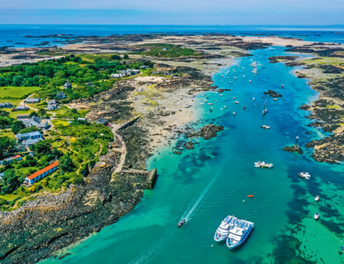
Now of course, there are all manner of wonderful gems to be found in and around the Fal Estuary – St Mawes, the Percuil River, Mylor, Flushing, to name but a few. The Fal’s wooded shores are steeped in history and have seen more than their fair share of privateers, pirates and illegal contraband. The flooded mud and shingle shores of these creeks can sometimes boil with grey mullet searching out small crustaceans, ragworm and other estuary dwellers. It’s certainly a sight to see if you ever have the privilege! But, resisting the urge to enter the wide-mouthed entrance to the Fal, marked in the east by the stark, whitewashed form of St Anthony’s Lighthouse, if you continue instead to cross Falmouth Bay, some 5 miles west of you you’ll spy a low-lying, densely treed cut in the coastline. This now marks the entrance to the Helford River.
Here lies yet another gem in Cornwall’s coastal crown – one that has been appreciated by yachtsmen for decades now. The Helford’s riverbanks, clad as they are with ancient oak forest, offer a haven for much rare wildlife. Little wonder this most westerly of all England’s wooded estuaries is so renowned for its outstanding natural beauty. The little coves of Durgan and Polgwidden on the Helford River’s northern shore, just tucked around Toll Point, are truly delightful. The former offers a protected anchorage amid its moorings, and the latter, being owned by the Trebah Estate, is famous for the outstandingly beautiful subtropical gardens that nestle in the valley directly behind the beach.
Notwithstanding its solitude and beauty today, some 70 years ago the idyllic Polgwidden was a covert location where large numbers of American troops bound for Normandy and the D-Day landings made their final embarkation before taking to the Channel. But now, with the concrete ramparts and slips built by the military all finally removed, Polgwidden’s sandy serenity has been restored as part of Trebah’s incredible subtropical garden experience. A project first initiated back in 1838 by wealthy businessman Charles Fox, today the gardens and the beach are open to the public, making Trebah well worth a visit if you venture here with half a day to spare.
Helford’s Frenchman’s Creek, immortalised by Daphne du Maurier in her book bearing its name, lies below Kestle on the opposite shore of the inlet with Port Navas at its summit. As if trolling up a leafy tunnel, you’ll find nowhere more romantic if you’re seeking a place to conjure thoughts of smugglers dipping their oars in still, dark waters as they silently steal upriver to offload their haul.
Thatched roofs, whitewashed walls and little gardens bright with flowers contribute much to Helford village’s picture postcard beauty. Nestled on the southern shore of the river, it’s a delightful spot to step ashore, spend a while musing, skim stones or settle down to lunch. Be mindful not to get in the way of the little ferry that runs to and fro out to Helford Passage if you’re alighting here, though. But if you are putting in here for something to eat, then the Ferry Boat Inn has a five-star rating. Within its original wooden-beamed interior, the menu offers fine fresh fish and locally sourced seafood. All in all, though navigating its upper reaches and creeks is subject to being tidal, the Helford is truly a diadem clustered by many gems and worthy indeed of investigation.
Lobster Pots & Pasties
Pressing on past the ominous-sounding Black Head, west of Coverack (the latter being another very worthy little port of call that features a busy, but tiny, drying fishing boat harbour and a former lifeboat house, now famous for its highly esteemed fresh seafood), you will, on a due west course of 5 miles, come to Cadgwith. This quintessential example of a Cornish fishing hamlet has been a favourite haunt of artists for well over a century now, being attracted, as they are, by the region’s favoured light and Cadgwith’s undeniable beauty. For the visiting mariner too, it really is a delightful place to go, and perhaps pull into, while on passage to or from the Scilly Isles. As long as the sea state is settled, anchoring off the beach among the small number of local moorings presents no problem at all. Just be careful that your anchor line is not of such a generous length that your boat picks an argument with the rocks located on the cove’s eastern face. Again, it’s the sort of place where it’s useful to have a small tender of some kind to get ashore, which saves the last man having to don a drysuit and swim for it!
The small shingle beach at the foot of the village with its stone fishing huts at its head is generally busy with the activities of the local fishermen, either winching their craft ashore, unloading a catch of crab and lobster or quietly sorting their nets and fishing gear. If your visit coincides with a ‘working day’ such as this, it only adds to the flavour of Cadgwith’s uniquely picturesque surroundings. With at least two good places to eat serving local catch and traditional favourites including pasties, as well as a coffee house bistro, the hamlet is more than able to satisfy the needs of the hungry mariner. Cadgwith may be small in form, but its beauty is great and rich in detail.
Amid the clatter of gulls and the heady smells of stacked lobster pots, no doubt you’ll find pleasure being in the company of fishing nets and hemp rope, brightly painted Cornish ‘crabbers’, and the serpentine stone cottages with their centuries-worn thresholds and weathered wooden shutters. These are just some of the rustic delights loved by artists seeking to capture Cadgwith on canvas, but of course, they await those of us too who choose to venture this far west by boat, to this last precious haven east of the Lizard.
Upon leaving Cadgwith, look out for the ‘Devil’s Frying Pan’, just a mile south-west of the hamlet. The collapsed roof of a sea cave in the cliffs has since left an arched entranceway and a deep cliff-sided pool beyond. When the gales blow and the sea thunders in, this geological wonder lives up to its name in a fear-inspiring way! Upon leaving here to head out through the overfalls and turbulent waters off Lizard Point, be sure once round the point to then follow the line of the coast north-west for a mile, so as to pay a visit to Kynance Cove.
Seals & Asparagus
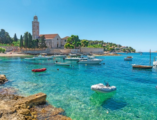
In my view, Kynance at mid to low tide is a true gem among gems – arguably the most scenic, most beautiful sandy cove or little bay to be found along the entire south coast of England. Edging out around and in between the towering rocks that mark its western flank, including the mighty Asparagus Rock, Kynance’s rock formations are a princely wonder to behold, especially when seen at half-tide. Seals and even dolphins are known to frequent the waters here, and on a summer’s day with the sun high in the sky, the water appears as clear as crystal beneath the hull of the boat. It may surprise you, but it’s a place you’d likely pass by without noticing at all if you were a mile offshore, as its profile, like many coastal features, would largely blend into the profile of the coast. But to take the trouble to pull in, to pause and savour the splendour of the place, and to sample its allure, is a delight you will never forget. Such is the beauty of Kynance Cove.
Tragedy & Loss
I had intended to finish my article at this point, but I couldn’t resist mentioning by way of a sign-off two last favourites of mine. The first, located out across Mount’s Bay and within sight of the great St Michael’s Mount itself, is once again a fishing village, one with a snug, drying, sandy-bottomed harbour. Before Newlyn was developed in the Victorian era, this village, located on the heel of the Land’s End peninsula, was Cornwall’s most notable fishing harbour. Its name? Mousehole, of course. Be prepared to dry out here, but as long as you plan your tides accordingly, if you’re looking for something a little out of the ordinary, then you won’t be disappointed in what Mousehole has to offer the more adventurous explorer wanting to venture off the ‘beaten track’ – a village that was sacked by the troops of no less than three Spanish men o’ war in 1595, and then again suffered tragedy in 1981 when all eight men serving aboard the RNLI lifeboat Solomon Brown lost their lives when going to the rescue of the coaster Union Star in the teeth of a hurricane on the night of 19th December 1981. (You can still visit the now disused Penlee lifeboat house, as it’s located just a short walk outside Mousehole village.) If you wish to stay overnight and not rough it on board, then the most likely suggestion for a hot bath, a good meal and a comfortable bed would be The Old Coastguard Hotel, overlooking the harbour. Mousehole brims to the rafters with maritime folklore and is steeped in seafaring history. Though perhaps worthy of only a short stay, it is as an old Cornish fishing village of much character and renown should be, not least due to the fact that it is home to the legendary ‘stargazy pie’!
Golden Sands & Wild Flowers
Finally, my last little gem is quite possibly one of the most beautiful beaches not just in the UK but in the world. It is Treen, on the Land’s End peninsula, famous for the balancing natural marvel that is Logan Rock. Some 66 tons in weight, this giant boulder atop the beach’s promontory can be rocked, they say, with just a hefty shove! A natural wonder indeed, but then again, so is the entire cove. Located approximately 6.5 miles west of Mousehole near the village of Porthcurno and the spectacular, ‘hewn out of the very cliffs’, Minack Theatre, the golden-sand panorama that is Treen is a sight to behold, especially in late spring when the cliffs are a profusion of the most colourful, rare wild flowers. Visit by foot down the steep coastal path or pull into the bay in settled conditions devoid of swell – but be aware that there are undercurrents here that can draw swimmers into difficulty. So take time to watch the surface of the water before entering. My advice, if the wind direction has any east in it, would be to make use of the lee of the Logan headland and sneak in around behind the rocks to anchor in order to swim or tender it ashore. A good-sized Danforth anchor and at least 50 metres of line plus chain is the minimum requirement when cruising in these parts – as are a well-found and well-equipped boat.
So there you go. I hope you’ve enjoyed this little voyage of discovery, this journey back in time too along Cornwall’s fascinating coastline. These lesser-known destinations and places of interest tend not to feature on the cruising agendas of many, or get as much publicity as the better-known destinations. But in many ways, they epitomise the cream on Cornwall’s jam-laden scone! It is not an exhaustive list by any means, and in time we’ll bring you more, perhaps focusing on the north coast of Cornwall too. But if you’re heading west this summer, why not try building a few of these suggestions into your passage plan? Who knows what discoveries you might make along the way …
HMS
Harbours & Moorings
- HM Coastguard: 01326 317575, www.falmouth.co.uk/shopsandbusinesses/falmouth-coastguard
- Helford River moorings: www.helfordrivermoorings.co.uk
- Helford moorings officer: Ian Tolchard, 01326 250749 or 07808 071485
- Coverack harbour master: Jon Carey, jonharbourmaster@icloud.com, 01326 280638
- Cadgwith harbour master: Nigel Legge, nigann2000@yahoo.com
- Coverack harbour master: 01326 280679
- Mousehole Harbour Authority: 01736 732544 or 07891 647831
- Polkerris – 12 private moorings – no facility for public, can anchor up only for short stay
- Portloe – harbour run by local committee
- Fowey Harbour Commissioners – reception@foweyharbour.co.uk, 01726 832471
- Falmouth Harbour Commissioners: admin@falmouthport.co.uk,
- www.falmouth.co.uk, 01326 312285, offers useful marine info
Fuelling
Plymouth: 01752 671142; Falmouth: 01326 312285; Fowey: 01726 832471 (new for 2018, petrol & diesel now available in Fowey: www.foweyharbour.co.uk for more info & contacts)
Tourist Info
- www.visitcornwall.com
- www.letsgocornwall.com
- www.intocornwall.com
- National Trust: www.nationaltrust.org.uk
- SW Coast Path: www.southwestcoastpath.org.uk
- Caerhays Castle: www.helfordrivermoorings.co.uk
- Minack Theatre: www.minack.com
Taking Precautions
The beauty of exploring the coast at close quarters is that you don’t need or really want a big expensive vessel. In fact, a boat with a sizable waterline length and deep draught will be a definite disadvantage. Remember, to see the coast at its very best means you have to get in really close, within ‘spitting distance’ ideally, but of course, very great care has to be taken not to strike a rock in the process. So consulting a detailed chart or a pilot book on the region, appointing a good ‘rock watch’ lookout up in the bow and being aware of the dangers of an onshore wind or light reflection on the water’s surface are all essential precautions when venturing close in. Acquiring some good local knowledge can be really valuable too. When I wanted to explore the lesser-known islets, rock outcrops and reefs of the Scilly Isles, I used to take local maritime ‘sage’ Osbert Hicks with me on the boat. He was a wonderful old Scillonian who was only too delighted to act as our pilot through these notoriously tricky waters. His intimate knowledge of the wrecks and the archipelago’s history also really brought the whole experience to life.
Related Posts